
Healthy High Streets? Establishing a baseline and co-creating monitoring, in Glencoyne Square, Southmead

Posted on

by Rachel Alcock-Hodgson

How can a community know what impact their work has on their local area? What are the key features of a ‘Healthy High Street’ in a Bristol neighbourhood setting? Can monitoring be robust, community-led and place specific?

In summer 2024, we1  set out to collect information about the Arnside, Greystoke and Glencoyne shopping centre of Southmead, north Bristol. The specific aim was to establish a way to monitor the impact of Southmead Development Trust’s Glencoyne Square Community led housing project. The Glencoyne Square development consists of 187 community-led homes, plus commercial and community spaces. The development will hopefully increase density and hence footfall in the neighbourhood as well as providing much needed affordable housing in the area.

The first step was to review literature about health and high streets, and to assess the tools currently available to measure this.  There is somewhat of a split between those who research public health and are therefore interested in the impacts high streets can have on population health, and those who are more focused on economic performance as a measure of success / ‘health’. What is clear is that the ‘Health of the High Street’ is broader than just viability, it is also about vibrancy (see for example, Understanding your High Street Viability from the Institute of Place Management, 2022). This therefore has implications for how we measure it.

The project developed a bespoke monitoring approach for Southmead and SDT, drawing on the Place Standard tool2 (what people currently think about their place) and Public Life surveying (how people use the space at different times of day), but also incorporating specific retail/shopkeeper surveys and analysing the impact of design passive surveillance. These tools were explored and piloted with local groups including the trustees of SDT and ‘Team Southmead’ (a volunteer team of local residents). Interesting insights gathered here included views on the language used in the surveys- no-one talked about ‘the high street’, the area was described as ‘Arnside’, ‘Greystoke’ or ‘the shops’. Further, standard tools had the most frequent category for visiting ‘the high street’ as ‘more than once a week’, however many people stated they visited every day-something that would not have been accurately reflected in the broader categories we had formerly employed. These raise interesting questions about the mindsets and assumptions of people designing such tools, and the extent to which they are developed drawing on the lived experience of people from diverse neighbourhoods across the country.

We found that most people visit Arnside and Greystoke more than once a week.

Another nuance of terminology was revealed in questions about people’s impressions of the area. More than half of the respondents thought that Arnside and Greystoke are welcoming. However, in discussion, a lot of respondents made the distinction between ‘welcoming for me? Or someone else?’ Saying that they found it welcoming but thought that others might not, e.g. older or more vulnerable people, or people from other neighbourhoods.

The question about ‘healthiness’ was rephrased from the ‘Do you think the high street is a healthy place to be?’ to ‘Do you think Arnside and Greystoke help you to be healthy and make healthy choices?’ There was initially some debate how/if to include this question as some of the community development team did not feel it was very clear and it might switch people off. However, in delivering the survey, it actually went quite well and most people had an immediate reaction. If not, a useful prompt was ‘health means different things to different people – some people have thought about physical activity, some about food, some about mental health and socialising’.

More than half of respondents felt that Arnside and Greystoke do not help them to be healthy. A lot of people felt health was more about individual behaviour, rather than the design of the neighbourhood.

Through the responses to the Place Standard Tool assessment, we found that the areas with the biggest room for improvement are:

  • Being listened to and having a say (Influence and Sense of Control)
  • Care and Maintenance
  • Feeling Safe
  • Housing (Housing and Community),
  • Work, training and volunteering (Work and Local Economy).

Areas judged as good currently are moving around Arnside and Greystoke, people’s feeling of identity and belonging, opportunities for social interaction and the facilities and services on offer.

This impression was supported and extended through observing how people use Arnside and Greystoke, using the Public Life Survey framework. Specifically, this included observations that the benches are well used, despite their being criticised in some earlier feedback and discussions.

Image of the area

People use them to rest, enjoy the sun, sort their bags out, chat and eat and drink. Arnside and Greystoke are very social spaces – early in the morning when there was a gap in traffic noise, the noise of the street was a hubbub of people talking. Also, when observing groups of people staying still, it was common for group sizes to shift and change as people met each other and stayed to talk. In the evening, young people use Arnside and Greystoke to hang out. These detailed observations helped provide a fuller picture of the area, and will be important to replicate when assessing the impact of the Glencoyne Square development. The project also conducted a survey with local businesses and undertook a retail survey using the Royal Society of Public Health’s methodology. The latter again raised questions about the standpoints of those who devised it with charity shops and barbers not being categories that were listed, but both playing important and positive parts of Arnside and Greystoke.

Image of the area

So, wider reflections on the utility of this project will come in the following years, when this baseline set of findings can be compared to ones gathered after the development of Glencoyne Square. For now, however, three things stand out. First, the importance of university-community partnerships in developing mutually beneficial projects. We all have learned from each other in this work, and have made a firm basis for future collaboration. Second, the need for robust monitoring, but also the need for robust questioning of the assumptions and worldviews underlying some of the monitoring tools we have. Finally, the importance of using critical understanding and local knowledge in supporting innovative and meaningful community developments.

  1. Rachel Alcock-Hodgson, a UWE MSc Urban Planning student, with a little bit of help from Katie McClymont, Associate Professor in Urban Planning, alongside Cecilia Casadio, project leader Southmead Development Trust ↩︎
  2. https://www.ourplace.scot/tool ↩︎

Quality of life and access to green-blue-grey infrastructure in Bristol

Posted on

By Danielle Sinnett, Issy Bray, Harry West and Owain Hanmer

A recent study, using Bristol City Council’s Quality of Life data, has found that neighbourhood satisfaction, wellbeing and life satisfaction are all related to how satisfied residents are with their greenspaces.

Mental health, particularly for urban populations, is a growing public health concern. There is good evidence about the importance of green and blue infrastructure, including parks, street trees, rivers and other water features, for the wellbeing of urban residents. There is also emerging evidence about the benefits of certain ‘grey’ features, such as historic buildings and transport infrastructure, including active travel routes and public transport. Other features, such as proximity to heavily trafficked roads or derelict buildings, are associated with negative impacts. To date, these different forms of infrastructure have tended to be explored individually rather than looking at the complex interactions between them.

It is important to plan and develop towns and cities that maximise population wellbeing, and related health and social outcomes, at the same time as contributing to the sustainability agenda. Our increasingly urban economy has deepened inequalities, which we know to be a driver of poorer physical health, life satisfaction and other social outcomes. We also know that interventions that are accessible to everyone, like green-blue-grey infrastructure, are one of the most effective approaches to reducing inequalities.

Our approach

Our research used Bristol’s Quality of Life data as well as data on the green (e.g. proximity to parks, neighbourhood trees), blue (e.g. proximity to rivers) and grey (e.g. access to bus stops, density of listed buildings) infrastructure in the city to investigate relationships between green-blue-grey infrastructure and a range of health and social outcomes in neighbourhoods across Bristol.

The Bristol City Council Quality of Life survey has been running since 2001 and provides an annual snapshot of the quality of life across Bristol. The survey includes up to 190 indicators of quality of life and wellbeing of residents, and between 3,000 and 5,000 Bristol residents respond each year. Our project analysed anonymised data from 2011-2022 using geographical information systems and logistic regression models to explore the associations between green-blue-grey infrastructure and the following self-reported outcomes:

  • Neighbourhood Satisfaction
  • Life Satisfaction
  • Wellbeing (Short Warwick-Edinburgh Mental Wellbeing Scale)
  • General Health (self-reported over 12 months).

We took sociodemographic neighbourhood factors into account in the analysis. Importantly, the Quality of Life Survey also asks residents about their satisfaction with green-blue-grey infrastructure, including local greenspaces, bus services, leisure and cultural facilities. This meant that we could explore people’s perceptions of these features as well as their distance to people’s homes. This is useful as we know that sometimes people can feel that local facilities are not accessible to them even though they might be close to home.

Model for the relationship between green-blue-grey infrastructure, and general health and wellbeing.

Key findings

Interestingly, none of the measures of proximity to greenspace, rivers, amenities or neighbourhood levels of greenery were significantly related to the health-related outcomes we examined.

However, those who were more satisfied with their greenspaces were more likely to have greater levels of neighbourhood satisfaction, life satisfaction and wellbeing. It is difficult to tell how people interpret satisfaction with greenspace and it is likely that they are thinking about the availability of greenspaces within their neighbourhood, the city as a whole and the quality of those spaces. This is important as many studies only explore proximity and often fail to find a relationship, whereas examining how people perceive their greenspaces might be a better measure.

Similarly, in terms of grey infrastructure, residents who were more satisfied with their local amenities were also more likely to be satisfied with their neighbourhoods and have greater life satisfaction. Specifically, satisfaction with museums was related to both these outcomes and satisfaction with leisure centres, bus services and libraries was related to neighbourhood satisfaction.

Those who felt a greater sense of belonging in their neighbourhood, and those who were more satisfied with the safety and noise levels in their neighbourhood, and neighbourhood noise were also more likely to have greater neighbourhood and life satisfaction. Levels of street litter were also related to neighbourhood satisfaction.

Some unexpected findings were that those who lived further away from outdoor leisure centres were more satisfied with their neighbourhoods, and those in neighbourhoods with less garden coverage had greater life satisfaction and those further from a train station had greater wellbeing. We think this may be due to differences between more urban and suburban neighbourhoods that tend to have worse access to other amenities. Similarly, those who lived closer to a bus stop had lower life satisfaction, which could be due to heavily trafficked nature of the main roads in the city, which tend to also be the major bus routes (i.e. this is actually measuring dissatisfaction with living close to busy roads).

We did not find a relationship between any of the green-blue-grey infrastructure factors we explored and general health, which was very strongly associated with socioeconomic factors.

Summary of findings

Conclusions

Satisfaction with greenspace was the most consistent predictor of the wellbeing outcomes we considered. There was notable variation across the city, for example, neighbourhoods in South Bristol have similar levels of greenspace access and greenery as those in North Bristol, but greenspace satisfaction in these areas is much lower. This emphasises the importance of the quality of greenspace, and other improvements to neighbourhood infrastructure, for example, to enable people to visit their greenspaces.

Further information

We have produced a Story Map where you can explore some of the data: https://arcg.is/08WSir

And an animation: https://youtu.be/4TueNcibsmM

Reflection on a summer internship at UWE to explore the intersection of urban planning and sustainability

Posted on

by Lydia Mahan

After completing my BSc in Urban Planning at the University of the West of England (UWE) earlier this year, I had the opportunity to dive deeper into the world of research through a summer internship with the university. This was an exciting and insightful experience, offering me a unique chance to explore the intersection of urban planning and sustainability—two topics I am passionate about.

The focus of the internship was exploring how to evaluate the transition from what is granted in a planning permission to the later development stages in housing projects, specifically looking at the incorporation of social and sustainability features. These features included essential elements like affordable housing, play spaces, Sustainable Urban Drainage Systems (SuDS), wildflower planting, and the installation of bird and bat boxes.

This internship was my first experience of research at this scale, and I was eager to develop my research skills. The project’s broad scope presented both challenges and opportunities, I quickly realised how crucial it was to define the project boundaries and expectations. To do this, I engaged with the project leads and conducted an initial review of the source materials. This allowed me to understand the types of housing developments I needed to focus on and how to effectively use tools like the RAG (Red, Amber, Green) assessment tool to evaluate the sites.

One of the sites reviewed during the internship (Alexandra Gardens, Crewe)

One piece of advice I would give to anyone embarking on a similar project is to make sure you are actively engaging with your supervisors and taking detailed notes throughout the process. The feedback and ongoing conversations I had were instrumental in guiding my research, and having a comprehensive record allowed me to track my progress and double-check information from weeks prior.

One of the things I enjoyed about this internship was its independent nature. It gave me the freedom to explore the research process whilst getting a firsthand look at some of the challenges the planning world faces. For example, one of the hurdles I encountered was the difficulty in accessing planning application documents. One council’s planning portal did not allow me to search using postcodes, so I had to rely on identifying planning reference numbers to find the necessary documents which was far more time-consuming.

This challenge made me reflect on the importance of accessibility when it comes to planning documents as it is important for local communities to be able to easily access these resources for effective public engagement.

Completing this internship at UWE was more than just a valuable learning experience—it solidified my passion for research and equipped me with the skills I need to pursue my PhD at the University of Sheffield. The opportunity to work on such a real-world project has given me a deeper understanding of the complexities of urban planning, and I am excited to continue building on this foundation in the years ahead.

This internship not only helped me hone my research skills but also reinforced my belief that sustainability must remain at the core of urban planning. I look forward to exploring more opportunities to contribute to this field and tackle challenges that lie ahead.

Bio: Lydia Mahan graduated from BSc Urban Planning in July 2024 with a first-class honours degree.  She is now undertaking a funded PhD studentship at the University of Sheffield entitled “Measuring the environmental benefits and social impacts of large scale Sustainable Drainage Systems”.

The internship project was lead by Katie McClymont, with Hannah Hickman and Nick Croft on the team too, building on their report for the West of England Combined authority entitled ‘The whittling away of wonderful ideas: post-consent and the diminution of design quality’ https://www.rtpi.org.uk/policy-and-research/research-and-practice/planning-research-matters/planning-and-design/the-whittling-away-of-wonderful-ideas-post-consent-and-the-diminution-of-design-quality/‘

Transportation and Integration: Challenges for Asylum Seekers and Refugees in Bristol

Posted on

by Reem Elnady

Transportation is a cornerstone of integration for asylum seekers and refugees, serving as a vital link to education, healthcare, employment, and social connections. It fosters a sense of belonging and enables individuals to participate fully in their host communities. However, in Bristol, the cost and accessibility of transportation pose significant challenges for many asylum seekers and refugees, hindering their ability to rebuild their lives and integrate effectively.

During my research on the integration of Muslim women refugees in Bristol, I identified mobility and accessibility as critical barriers. Many asylum seekers and refugees face difficulties navigating the city due to limited transportation options and the high cost of bus fares. These challenges disproportionately impact women, who often carry caregiving responsibilities and depend heavily on public transportation to fulfil their daily needs.

A particularly pressing issue is the lack of support for asylum seekers housed in temporary accommodations such as hotels. For instance, individuals are not eligible for free bus tickets if the distance between two stops is less than three miles, regardless of health or mobility constraints. This policy effectively prevents many from attending language classes and acquiring the skills necessary for integration. Without adequate transportation, these individuals remain isolated, unable to access essential services or seize opportunities for personal and professional growth.

The financial burden of transportation is a recurring theme among asylum seekers and refugees. A mother receiving limited benefits shared her struggle: “We stay at home because if we go out, we pay a lot, and we don’t have the money.” This stark reality underscores how even modest transportation costs can immobilize families living on constrained budgets, leaving them with few opportunities to break free from their isolation.

The challenges become even more acute for women with caregiving responsibilities. One mother of five, relocated by the Home Office to a larger house to accommodate her family, faced significant difficulties despite the improved living space. Her disabled daughter’s school was an hour-long bus ride away, requiring the mother to leave home at 6 a.m. and return at 6 p.m. each day. With minimal benefits and no financial assistance for transportation, she had to cover the bus fare herself, exacerbating the financial strain on an already challenging situation.

A Call to Action: Free Bus Tickets for Asylum Seekers and Refugees

These stories reveal how transportation, rather than being a bridge to integration, often becomes a barrier for asylum seekers and refugees in Bristol. The cost and inaccessibility of public transportation limits their ability to engage in community life, access essential services, and build meaningful connections. Women, as primary caregivers, face unique challenges navigating the city while balancing their roles as caretakers and active community members.

To uphold Bristol’s reputation as a City of Sanctuary, it is imperative to address these transportation barriers. Providing free bus tickets for asylum seekers and refugees is not merely a practical measure—it is a moral obligation. Affordable and accessible transportation is a foundational step toward integration, enabling individuals to learn, work, and contribute to their host communities.

The Bristol City of Sanctuary Transport Fund serves as a vital example of community-led efforts to tackle this challenge. This initiative provides much-needed funding for transport, ensuring that people seeking sanctuary in Bristol can access essential services and appointments. However, more support and expanded measures, such as free bus tickets, are necessary to fully address the pervasive barriers faced by asylum seekers and refugees in navigating the city.

By removing these barriers, Bristol can truly embody the values of inclusivity and sanctuary it seeks to uphold. Transportation is not just about mobility—it is a key to integration and opportunity. Now is the time to act and ensure that our city remains a welcoming and supportive haven for all.

Image credits: Reem Elnady, Doctoral Researcher- UWE Bristol

Walking interviews as a research method

Posted on

By Yarden Woolf

Literature tells us a walking interview is when a researcher walks alongside a participant during an interview (Kinney, 2017). This process usually involve a researcher accompanying participants and speaking with them, usually on foot and in a specific location (Kinney, 2017). Specifically, walking interviews have been used as a method to explore experience (Braun and Clarke, 2013), as they can produce rich data by allowing participants to be in the environment being discussed (Evans and Jones, 2011).

I first used this method during my MSc in Urban Design and City Planning at UCL. There, I walked with participants along the Regent’s Canal in London, to understand how they experience it, and how this relates to the canal’s design. As part of this study, I walked with canal-users from Granary Square to Camden Market, asking them questions about their activities, perceptions and emotions while walking and cycling along the canal. Through this, I discovered how different participants experience the canal, and which of its spatial attributes (e.g., paths, vegetation, location, access, outdoor furniture) affects their experiences and how. I am currently in the process of co-authoring a paper to publish these results. Figure 1 was taken during one of the walking interviews in the Regent’s Canal.

Figure 1 – Regent’s Canal in London (2017)

These days, I am in my third year of a PhD research at UWE Bristol, and my study explores the relationship between students’ experience in greenspace, nature connectedness and pro-environmental orientation. I am looking at university students from both UWE and the University of Bristol, and utilising semi-structured walking interviews as one of my data collection methods. As shown by previous studies, this method is particularly beneficial for examining the relationship between experience in greenspace and physical attributes of the greenspace (Veitch et al., 2020). The use of walking interviews in social research has been increasing, particularly to explore the connection between self and place (Heijnen, Stewart and Espiner, 2022; Kinney, 2017).

During one of these interviews, I walked with a participant in St. James Park in the city centre. As we were walking around, the participant explained he suffers from anxiety and whenever he needs to, he visits this park, sits on a bench, and writes in his journal. He further described how looking at the light shining through the trees and hearing birdsong allows him to relax, and that he always feels calmer when leaving this part than when he walked in. Figure 2 depicts the views this participant mentioned as helping him relax.

Figure 2 – St. James Park (2024)

In another walking interview, I walked around UWE’s Community Garden (figure 3) with a participant who spoke about the key role this greenspace plays in providing him with an escape from lectures and assignments. This emphasises students’ need for accessible greenspaces on campus. This participant also mentioned seasonality, and how he enjoyed seeing this greenspace transform through the seasons, watching vegetation grow and change colours, and listening to birds who frequent this space.

Figure 3 – UWE Community Garden (2024)

As I reflect on these walking interviews and the data collected, I remember what it is that made me chose this method. First, engaging in conversation while walking creates an informal atmosphere, particularly when interviews are participant-led (e.g., participants choose the greenspace and route). Second, exploring the greenspaces with participants enabled me, the researcher, to better understand their emotional and perceptual experiences. Third, being at the greenspaces evoked memories in participants, reminding them of experiences they may have not recollected through other form of interview (such as pictures).

I would like to end with Wordsworth’s poem, which to me encapsulates what walking in nature is:

‘Sweet was the walk along the narrow lane
At noon, the bank and hedge-rows all the way
Shagged with wild pale green tufts of fragrant hay,
Caught by the hawthorns from the loaded wain,
Which Age with many a slow stoop strove to gain;
And childhood, seeming still most busy, took
His little rake; with cunning side-long look,
Sauntering to pluck the strawberries wild, unseen.
Now, too, on melancholy’s idle dreams
Musing, the lone spot with my soul agrees,
Quiet and dark; for through the thick wove trees
Scarce peeps the curious star till solemn gleams
The clouded moon, and calls me forth to stray
Thro’ tall, green, silent woods and ruins gray’

Yarden Woolf is a fully funded PhD researcher at UWE Bristol, landscape architect and urban planner. If you have any questions, feel free to email yarden.woolf@uwe.ac.uk

References cited in this blog:

Braun, V. and Clarke, V. (2013) Successful qualitative research: a practical guide for beginners. Los Angeles: SAGE.

Evans, J. and Jones, P. (2011) The walking interview: Methodology, mobility and place. Applied Geography [online]. 31 (2), pp. 849–858.

Heijnen, I., Stewart, E. and Espiner, S. (2022) On the move: the theory and practice of the walking interview method in outdoor education research. Annals of Leisure Research [online]. 25 (4), pp. 529–547.

Kinney, P. (2017) social research Update – Walking Interviews [online]. Available from: https://grandmas-story.eu/media/com_form2content/documents/c3/a203/f38/SRU67.pdf.

Veitch, J., Flowers, E., Ball, K., Deforche, B. and Timperio, A. (2020) Exploring Children’s Views on Important Park Features: A Qualitative Study Using Walk-Along Interviews. International Journal of Environmental Research and Public Health [online]. 17 (13), p. 4625.

Some reflections on learning on the job …

Posted on

by Hannah Hickman

I teach a module on our postgraduate distance learning course – Planning and Urban Leadership – called “Managing Strategic Growth”.  It is framed around encouraging students to think at scale, and critically evaluate the role of planners and planning in growth management, with a focus on population, household and economic growth and the resultant demand for more homes. At its heart it’s about just that, growth.

I inherited this module from an excellent former colleague, and over time I have re-oriented and shaped the module in response to some of the more recent developments in policy and practice.  However, full disclosure, over the Summer I reflected that I hadn’t previously encouraged students to do enough critical engagement with the concept of growth. I’m not saying we didn’t do any but perhaps an acceptance of the growth orthodoxy in planning was subliminal, somehow inadvertently built-in to the module’s design.

What prompted this reflection? I’m not sure I can pinpoint a precise moment, but I was immediately irked by the repeated statements that emerged very quickly from the incoming Labour Government, that put planning and growth facilitation, particularly economic growth, front and centre of its reform agenda. This is just one example of many:


“The Government has made clear that sustained economic growth is the only route to improving the prosperity of our country and the living standards of working people … Nowhere is decisive reform needed more urgently than in our planning system”[1].

Ascribing this role to planning is of course, neither new, nor a surprise. Many planning scholars have written engagingly about the growth fixation “inscribed in planning instruments” and “the often‐unquestioned growth bias in spatial planning that is institutionalized at all scales of land‐use planning”[2].

However, the disappointment I felt at the lack of wider narratives emerging from the new Government about both planning and growth, led me to both re-engage with some of the important existing scholarship in this area, but also to read some recent literature for the first time. In short, in preparing for this module, I went down an utterly engaging rabbit hole. Amongst other things:

  • I read the excellent piece by Jin Zue on de-growth, challenging ‘smart-growth’ (the apparently false win-win scenario to support growth), and encouraging “subversion of planning’s commitment to growth … and resuscitation of utopianism” [3], anddipped into Savini’s volume on Cities beyond the market economy [4];
  • I looked beyond planning, to see what scholars in politics and public policy have been saying. In short, questioning the economic growth paradigm is happening across disciplines[5];
  • I listened to the economist, Kate Raworth, talk engagingly about her book ‘doughnut economics’, in which she questions whether governments “are right to think that the solution to their economic problems lies in more growth” [6]; and 
  • I explored the many and various ways of measuring growth that go beyond GDP, and here I would give a massive shout out to UCL’s citizen prosperity index [7].

I also did a very cursory piece of research to look at the national planning policy statements of the UK’s devolved nations, and I was surprised at what I found. Scotland’s National Planning Framework 4, makes 104 references to growth, although in many and varied ways, including  ‘compact growth’,‘green growth, ‘greener growth’, and ‘inclusive growth’.  Future Wales: The National Plan 2040, containsa whopping 296 references to growth, including ‘sustainable growth’, ‘inclusive growth’, ‘nationally important growth’, ‘clean growth’, ‘green growth’, and ‘inclusive growth’. The Strategic Planning Policy Statement for Northern Irelandhas 42 references to growth, but with an overwhelming focus on economic growth. The idea of growth – in all sorts of guises – is the undoubtedly orthodoxy in these statements, paralleling the English narrative.

So, what did I do when I climbed back out of the rabbit hole? Well, initially at least I’ve shared a few observations (for what they are worth!) with the Planning and Urban Leadership students and asked them to think about where they sit on the pro-growth, de-growth axis, and to reflect upon what role they think planning (and planners) should take in this.

But why have I decided to write about this here, albeit very briefly? There were two motivators. The first, was to highlight the value of ‘learning on the job’ (as well as the privilege of being able to do so) and the fundamental importance of ensuring that as educators we are striving, as far as is possible, to keep up-to-date (accepting – by the way – that this is almost impossible in such a fast moving area of policy and practice!). Secondly, and perhaps more importantly, is the need to continue to encourage critical thinking in our students. In sharing my insights, I have not said that they should be anti-growth, or that there isn’t an inter-relationship between planning and growth that needs to be understood, but I have encouraged them not to accept things just as they are. This now feels like an omission in my previous teaching on this module.

Finally, and another shout-out, this time to the international student who spontaneously shared (today!) that their favourite part of the Managing Strategic Growth module so far had been the lecture and wider reading on ‘challenging the growth orthodoxy in planning’. That was enough to post-hoc justify the rabbit hole down which I went!

Featured image credit: https://www.growthforce.com/blog/5-stages-business-growth


[1] Ministry for Housing Communities and Local Government (2024). Proposed reforms to the National Planning Policy Framework and other changes to the planning system https://www.gov.uk/government/consultations/proposed-reforms-to-the-national-planning-policy-framework-and-other-changes-to-the-planning-system

[2] Lamker, C. and Terfrüchte, T., (2024). Post-growth ambitions and growth-based realities in sustainable land-use planning. Urban Planning, 9, 1-16.

[3] Xue, J (2022). Urban planning and degrowth: a missing dialogue, Local Environment, 27 (4), 404-422.

[4] Savini, F., Ferreira, A. and von Schönfeld, K. eds., (2022). Post-growth planning: Cities beyond the market economy. Routledge.

[5] Warner, S., Newman, J., Diamond, P. and Richards, D., (2024). The challenge of devolved English governance and the rise of political spatial inequality. Parliamentary affairs, 77 (4) 735-764.

[6] Raworth, T. (2018). A healthy economy should be designed to thrive, not grow. https://www.ted.com/talks/kate_raworth_a_healthy_economy_should_be_designed_to_thrive_not_grow/transcript?subtitle=en

[7] UCL Institute for Global Prosperity. (2024). The Citizen Prosperity Index. https://www.ucl.ac.uk/bartlett/igp/research/citizen-prosperity-index

Spark the Future

Posted on

by Elahe Karimnia

The vision for rejuvenating high streets through meanwhile projects—temporary use of vacant spaces—is gaining momentum. This approach is capturing the interest of local authorities, property owners, and developers as it offers a response to contemporary crises. While neoliberal strategies have often driven temporary uses of space, post-pandemic Europe has come to recognise the value of grassroots initiatives in reclaiming space for community purposes. Temporariness should not be seen as a short-term solution, but rather as a window of opportunity, capable of disrupting conventional urban design and development processes related to property ownership and land use. Critical temporary practices hold the potential to challenge the notion of vacancy and the (re)production of uneven conditions of development – outcomes of capitalist spatial relations. These practices create opportunities for more equitable access to properties, innovative governance structures, and diverse financial models. However, challenges, and dynamics within such ‘meanwhile’ warrant further exploration.

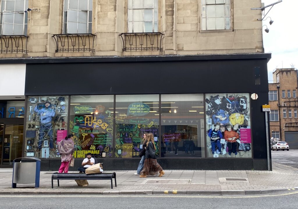
Figure 1Sparks shopfront on The Horsefair. Credit: Elahe Karimnia

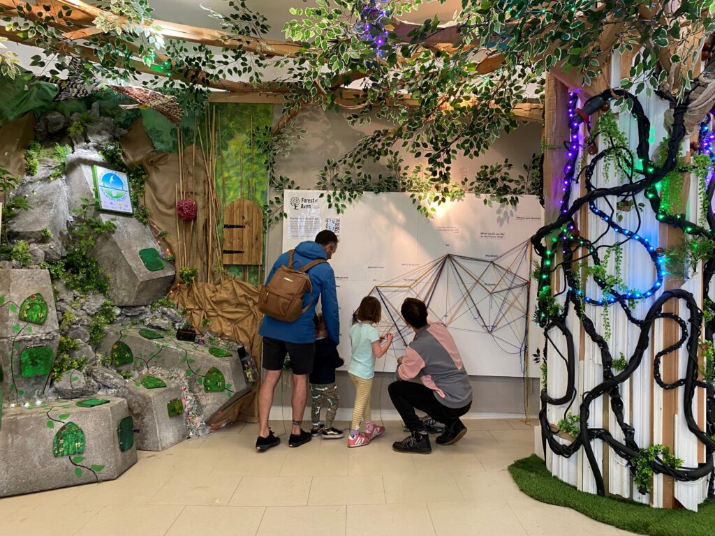
Sparks Bristol stands as an exemplar, showcasing an equitable future that transcends conventional retail and consumption models in city centres. Launched in 2023 through a partnership between Artspace Lifespace and the Global Goals Centre, facilitated by Bristol City Council (BCC), Sparks repurposed a former Marks and Spencer building in Bristol’s city centre. By creating a different department store in which sustainability is addressed via education, arts and culture, Sparks has pushed the boundaries of traditional retail, reusing large vacant properties like department stores, whose emptiness can detract from the vitality of high streets and the collective memory of communities.  Due to its success, Sparks has received an extension and will continue until December 2025.

Figure 2 Sparks’ Department of Nature. Credit: Elahe Karimnia

Alongside my colleague from the School of Arts, I joined the project as a critical friend and contributed to the writing of an interim evaluation report. Drawing from my previous research on spaces and infrastructures for cultural production, and other meanwhile projects such as The Space, and Coco Velten, I recognised that a major challenge for such projects is the lack of time and resources to capture and document the knowledge that emerges throughout their processes.

As finances and governance in these projects tend to evolve over time, it is important to assess their success based on their capacity for agility and adaptation, rather than rigid goals. Within our constraints, the interim evaluation report highlights how Sparks has fostered an alternative vision for the city centre, integrating sustainability, creativity, and circular economy principles—elements that are crucial for future urban design and development.

The report positions Sparks as a creative urban experiment. The project provides an innovative response to the complex challenges of high street revitalisation, especially in the context of austerity and shifting retail patterns. It also demonstrates an ethical model of practice, where partnership with local organisations and communities are pivotal. It also showcases the potential for community-oriented events through which inclusive spaces and encounters emerge.

The report underscores the key attributes of Sparks, including:

  • Reshaping high streets through innovative vision: integrating education, arts, and culture into traditional retail spaces, with sustainability at the core.
  • Robust partnerships and a versatile financial model.
  • Art-led spatial adaptation, promoting accessible art and culture.
  • Engaging local communities, particularly marginalised groups, to foster inclusivity.
  • Open communication with stakeholders and building a community of practice with local partners.
  • Balancing public and private events, ensuring both community engagement and operational sustainability.

However, like many temporary cultural and community spaces, Sparks faces significant challenges particularly regarding financial stability. While funding support exists, maintaining a sustainable financial model proves difficult, especially without formal recognition of the financial benefits these projects bring to landlords, such as preventing rapid building decline. Additionally, future uncertainty—of what comes next after the temporary phase ends—can strain relationships with local and created communities.  Unforeseen building issues and required repairs may also add to project costs, exacerbating financial concerns.

Given Artspace Lifespace’s long-standing contribution to Bristol’s cultural scene, Sparks has sparked ongoing dialogues with local authorities about leveraging vacant properties for community benefit. The project also highlights the broader issue of inadequate planning guidance and support for meanwhile projects.

The report was co-authored with Dr. Tarek Virani and funded by the University of the West of England’s College-Building Fund. We extend our gratitude to Jenny Foster (Global Goals Centre) and Kathryn Chiswell-Jones (Artspace Lifespace), along with all contributors acknowledged in the report. The full report is available here.

For more information on the potential of temporary urban practices, please contact me at elahe.karimnia@uwe.ac.uk

SPE is hosting a major international conference in June 2025 

Posted on

by Robin Hambleton and Danielle Sinnett 

It’s exciting to be able to announce that our Centre will be hosting a major international conference on ‘Creating healthy and sustainable cities’ here in Bristol on 10-13th June 2025. 

Now is the time to submit your proposals if you would like to participate in this forward-looking international conference.  The conference aims to attract over 300 scholars from more than 30 countries, and we hope very much that it will stimulate a wide range of fruitful conversations on how to improve the quality of life in cities. 

The background 

During this last six months or so a small team of the Sustainable Planning and Environment Centre (SPE) researchers has been working closely with colleagues in the European Urban Research Association (EURA) to develop the agenda for this international conference.   

UWE played a critical role in creating EURA in the 1990s.  Ever since it was launched, in Brussels in 1997, the association has sought to encourage international exchange and cooperation in relation to urban and environmental studies.   

EURA conferences are interdisciplinary, stimulating and, also, very friendly!   

Apart from organising successful international conferences and workshops EURA runs a highly respected international journal – Urban Research and Practice – and provides a website that enables scholars to share ideas in an ongoing and active EURA Conversations series about the future of cities.  Click here for more information on EURA: EURA – European Urban Research Association

The EURA 2025 International Conference in Bristol 

The purpose of the 2025 conference is not just to advance understanding of how to create healthy and sustainable settlements in the UK, but also to contribute to international thinking relating to city planning, environmental innovation and local democracy. 

The aims of this conference are, then, closely aligned with the core aims of SPE.  By bringing together a large and diverse international group of scholars the conference should be able to advance international understanding of how to create places that are environmentally healthy, resilient and sustainable, in the context of the ecological and climate emergencies.

The EURA 2025 Conference website has just been launched and proposals are welcomed by 31st October 2024. 

More details 

This international conference will take place in Bristol City Hall in the heart of the city on 10-13th June 2025.   

Nine tracks have been created to guide the academic exchanges that will take place next June:

1. Creating healthy and liveable places

2. Regenerating the city

3. Smart city governance driving green and digital transitions

4. Regulating the city: planning and beyond

5. Enhancing democratic governance in changing cities

6. Strategic thinking for city futures: looking beyond city boundaries

7. Inclusive futures and spatial practices

8. Designing accessible cities: towards low-carbon and inclusive mobility futures

9. Greening the city

In addition to the academic discussions that will take place during these tracks, there will be contributions from high profile keynote speakers and an afternoon of mobile workshops.

These mobile workshops (or study tours) will enable participants to meet civic actors in different locations within Bristol who are trying to help Bristol become a healthy and sustainable city.  These grounded discussions with practitioners will form a very important part of this conference.

Ways of participating 

If the issues set out above interest you, please consider submitting a proposal to the EURA 2025 website.  The call invites participants to submit abstracts and/or to submit proposals for pre-organised panels or conversations. 

This is a chance to express our sincere thanks to the many colleagues within SPE, and beyond, who developed the successful bid to EURA to host the 2025 international conference here in Bristol.  Special thanks are due to colleagues who have agreed to co-chair the various tracks and to those who have agreed to lead the various mobile workshops.  Thank you! 

If you would like to find out more about this international conference, click here: EURA 2025: Creating healthy and sustainable cities, Bristol, UK, 10-13 June 2025.

Robin Hambleton is Emeritus Professor of City Leadership in the Centre. Danielle Sinnett is Professor in Sustainable Built Environments and Director of the Centre for Sustainable Planning and Environments.   

Ecotourism in the Egyptian Red Sea Parks: Challenges & Solutions

Posted on

by Amir Gohar

Following the 1979 peace treaty and the return of the Sinai Peninsula to Egypt in 1982, the country began focusing on its environmental assets, including national parks. Egypt’s national parks cover diverse environments, from mountains, deserts, and oasis to coastal and urban areas. Law 102 of 1983 authorizes the Prime Minister to designate areas as national parks, defining their boundaries and management principles. To date, 24 national parks have been established under this law.

The Red Sea parks are a unique, underutilized resource. However, tourism development has constantly threatened their fragile ecosystems. Despite initiatives to minimize these impacts, development patterns remain largely unchanged, and knowledge of proper landscape planning remained within limited number of professionals.

CHALLENGES OF CURRENT STRATEGIES

Ecotourism and national parks share a complex relationship. Balancing development and conservation is a contentious issue. Ecotourism is often seen as a way to ensure parks’ economic sustainability, but it carries significant risks, particularly in the case of the Red Sea.

1. Technical Challenges

(i)  Understanding of Ecotourism: Ecotourism is often misunderstood, with numerous definitions muddying its purpose. The International Ecotourism Society defines it as “responsible travel to natural areas that conserves the environment, sustains the well-being of local people, and involves interpretation and education”. In Egypt, this concept is not fully realised in park development, leading many projects to self-identify as “ecotourism” without meeting true environmental protection standards. Wadi El-Gimal National Park illustrates the need for better local understanding and institutional frameworks to develop eco-lodges.

Example of mangrove spread around the coastal stretch of Al-Qul’an Bay within Wadi El-Gimal National Park (Photo by Gohar)

(ii) Planning the Landscape: While experts in flora, fauna, geology, and marine environments contribute to park development, the spatial dimension remains underemphasized. Landscape planners, essential for designating protected areas and determining development intensity, are often absent from these processes.

(iii) Designing for Ecotourism (Eco-lodges): Egypt’s parks span diverse regions—mountains, oases, coastal plains—each with unique communities and building styles suited to local cultural and ecological contexts. However, most eco-lodge designs are either inspired by Nile Valley architecture or imported from countries with ecotourism traditions, neglecting Egypt’s diverse environmental needs.

2. Institutional Challenges

(i) Lack of Coordination between authorities: National parks fall under environmental authorities, while tourism projects are managed separately by tourism authorities. The lack of coordination between central and local governments hampers integrated planning and development solutions.

(ii) Insufficient Stakeholder Consultation: Local communities are rarely consulted on park plans, while developers often lack awareness of the local context, leading to issues like gentrification, relocation of communities, and negative impacts on livelihoods. Developers also risk building in ecologically sensitive areas, such as floodplains or mangrove zones.

(iii) Climate Change and Ecological Dynamism: Current shoreline regulations do not consider risks from sea-level rise or habitat changes, such as turtle nesting sites or mangrove zones.

(iv) Urban Expansion:
Increasing land values near cities have led to urban encroachment on parklands. Environmental authorities often allocate parkland for ecotourism projects to generate revenue, but the competition between land uses undermines conservation efforts.

SOLUTIONS & THE ROLE OF LANDSCAPE ARCHITECTS

Fieldwork in Egyptian national parks suggests that ecotourism can be part of the solution if the following recommendations are adopted:

1. Understanding the concept of ecolodge beyond architecture: Ecolodges often focuses on architectural aesthetics, which is too limited. Egypt’s parks encompass diverse social structures, including nomadic communities, and require localized parameters that go beyond vague recommendations like “using local materials”. These parameters should be integrated into environmental laws rather than optional guidelines.

2. Consult local community: Consulting local communities provides invaluable insights, such as historical knowledge of floods, wind patterns, and migratory paths of fauna. Public participation should be extensive, involving nomadic communities in the planning process and establishing communication channels between developers and local residents.

3. Role of landscape planners: Landscape planners are essential in integrating ecological and social aspects into park management. Their involvement can minimize resource conflicts and ensure that tourism development supports ecosystem sustainability. For example, in the Red Sea parks, landscape planners help preserve the roles of acacia and mangrove trees, vital to the ecosystem.

4. Land suitability mapping: Land suitability maps identify areas for protection and those less suited for development. This helps avoid placing tourism developments in vulnerable zones like floodplains.

Example of a dedicated tourism developer who placed the permanent structure out of the floodplain and salt marshes, which is not a common practice in the region (Photo by Gohar)

5. Prioritize parklands over real estate development: Parklands should not be forced to compete with real estate for value. Urban expansion should respect park boundaries, particularly in cities like Cairo, where space is limited.

National parks are crucial to Egypt’s environmental heritage, but they are under threat from urbanisation and unchecked tourism development. Involving landscape planners early in the decision making and development process can help protect these parks, minimise conflicts, and resolve ongoing challenges. Collaboration between local communities, developers, and planners is essential to ensure that ecotourism supports the environment rather than harms these delicate ecosystems.

Featured image credits: Mangrove patches looking towards Wadi El-Gimal Island (Photo by Gohar).

Nationally Significant Infrastructure Projects – the value in understanding implementation

Posted on

by Hannah Hickman

‘There is very little pre-existing research on project implementation and the impact that a planning consent has on this stage. Our research fills an important knowledge gap and is not only of significance to the planning profession, but to those in Government currently focused on the infrastructure planning reform process, and to project promoters and their consenting and delivery teams’.1

Described as ‘the most far-reaching legislation of its kind since 1947’2, the 2008 Planning Act in England introduced a new system for the consenting of infrastructure projects deemed in the national interest – nationally significant infrastructure projects (NSIPS). At the time of its inception, this legislation was seen as a ‘genuine revolution’3 in the handling of consents for large scale infrastructure developments.

The so called ‘revolutionary’ aspects of the new system included: the removal of infrastructure projects over a certain threshold from local authority decision making, with decisions taken following prescribed timescales by ministers of central government following the advice of independent inspectors; the combination of most – although not all – consents, including planning permission and compulsory purchase acquisition powers into one document to enable development to proceed, known as a Development Consent Order (DCO); and, critically, the expression of need for development in sector specific National Policy Statements, such that debate about the need for infrastructure takes place during parliamentary scrutiny of NPS preparation rather than on a project basis at examination.

Certainty and speed of decision were the defining logics of the new system and there is evidence to suggest that speed of decision making has been a positive outcome of the new system for many projects. However, speed and certainty of decision making, do not necessarily result in a faster or easier delivery process (presumably the ultimate intent of the new system …) or do they?

In 2023, the National Infrastructure Planning Association published research commissioned from UWE and the University of Sheffield to explore the relationship between consent and delivery – the journey from consent, construction and through to ongoing operation – framed by the question, ‘how can the Development Consent Order process be strengthened to better support the delivery of Nationally Significant Infrastructure Projects‘?

This research specifically focused on practitioner’s experiences of this post-consent delivery phase and involved detailed survey work, six in-depth case studies, and discussion with a wide range of bodies engaged in the NSIP process, including statutory environmental bodies and local authorities.

Hornsea II Wind Farm (Courtesy of Ørsted)

As a research team, it was fantastic to have the opportunity to talk to such a wide- range of professionals involved in the delivery of major infrastructure projects, from those in construction project management and contracting, to lawyers, environmental specialists, and of planners across both the public and private sectors. This experience left two lasting impressions on the team. Firstly, and maybe self-evident to those in the industry, the delivery of major infrastructure projects is a truly cross-sectoral endeavour. Those projects with a relatively smooth delivery phase demonstrated a clear commitment by all those involved, to understand the remit, constraints, and perspective of all the disciplines involved. Secondly, understanding the effectiveness of planning (a consent as granted) demands the insights derived from delivery: it materially effects not just the ultimate design of projects, but the delivery phase as well.

Key recommendations from the project included:

i. The importance of continuing to extend the opportunities for disseminating, sharing and reflecting on the experience of project delivery and implementation – this has been an overlooked area of practice;

ii. The need to ensure that any further reforms to the DCO process that focus on speed of decision making do not pass on problems to the delivery and implementation stage – speed of consent does not necessarily result in a smoother delivery phase;

iii. The need for a review of the further consents and licences required post consent – most infrastructure projects still require a number of additional consents before delivery can commence, causing uncertainty and delay;

iv. to consider a more supportive approach to post consent change management – the DCO post-consent change process is highly constrained and is both time-consuming and expensive;

v. The need for significant ongoing support for local authority and statutory body engagement in delivery and operation as well as examination – these organisations play significant roles at delivery yet face considerable resources constraints in doing so effectively;

vi. The need for greater consistency at project examination stage in how flexibility within consents can be justified and achieved – lack of flexibility to vary a scheme’s design, or deploy alternative construction methods, post-consent can cause delivery challenges; and

vii. The value in capacity building – across professions – to support delivery.

The project report, and detailed case studies, are available from:

https://nipa-uk.org/wp-content/uploads/2023/08/NIPA_Hindsights_Final_Report.05.07.2023.pdf

NIPA Insights III Supplementary Report (Case Studies) (05.07.23) (nipa-uk.org)

  1. https://www.rtpi.org.uk/policy-and-research/research/planning-research-matters/infrastructure-planning/practitioner-s-experiences-of-development-consent-order-implementation/ ↩︎
  2. http://www.theguardian.com/society/2009/jul/15/quango-fast-tracks-controversial-projects ↩︎
  3. https://www.jplc.org/files/pdf/attaining%20the%20age%20of%20consents.pdf ↩︎

Feature image: Tilbury2 in construction (Courtesy of Tilbury Port)

Back to top